Another big day today and an early start. 167 miles and nearly 8,000 feet of climbing are ahead. With the aborted ride yesterday, I was able to recover and hope I can complete the distance. The ride was originally going to end in Globe Arizona which was less than 100 miles away. However, due to the lack of satisfactory accommodations, we decided to extend to the next town that had something more suitable. Hopefully I didn't bite off more than I can chew.
I roll out at 5:30 am and the temperature is a icy cold 38 degrees. The Phoenix Metroplex is so large and sprawling that I really had to pay attention to my navigation to make it though the city and surrounding suburbs. Due to the cold and navigation issues, it took me two hours to go just 27 miles. Yikes, a 13.5 mph average on flat ground?!
I stopped at McDonald's to get a coffee and a biscuit for breakfast since I was feeling sluggish due to the cold. I don't know if I should feel offended when the McDonald's employee called out my order as "biscuit and a senior coffee." Do I really look that old?
After warming up a bit, I headed back out and reached the end of the Phoenix area. I was now on the highway leading towards Superior Arizona where I will take my next break. One of the best things about riding in this area is the conditions of the highway pavement. You can definitely tell which counties have the money and resources to maintain their roads. This area not only had smooth pavement, but it was clean and free of normal roadside debris. This made for swift traveling.
A few miles up the highway I came across a ranch that had a Renaissance Fair in the middle of a Saguaro Cactus field. I turned into the property to check it out, but unfortunately they were only open on weekends. I just seemed unusual to me to see an attraction like this in the middle of the desert.
I proceeded on and the day was finally warming up under the desert sun. I was also beginning one of the first of the big climbs of the day. I was about 50 miles into the ride and was facing a five mile climb averaging a 5% grade. Surprisingly I felt really strong and made good time. I don't think I dropped below 12 mph on any portion of the climb. However the sun was shining right in my face and I felt that my sunburn was getting worse, despite the sunscreen that I was applying regularly.
I crested the summit and had a nice down hill run of around four miles before starting the next climb towards Superior. This climb was over 10 miles long with Superior at the midpoint. The climb to Superior only averaged 4% grade but the climb after would hit sections of up to 10% and go through a tunnel about 1/4 mile long. I would worry about that later, first I wanted to get to Superior and take another break.
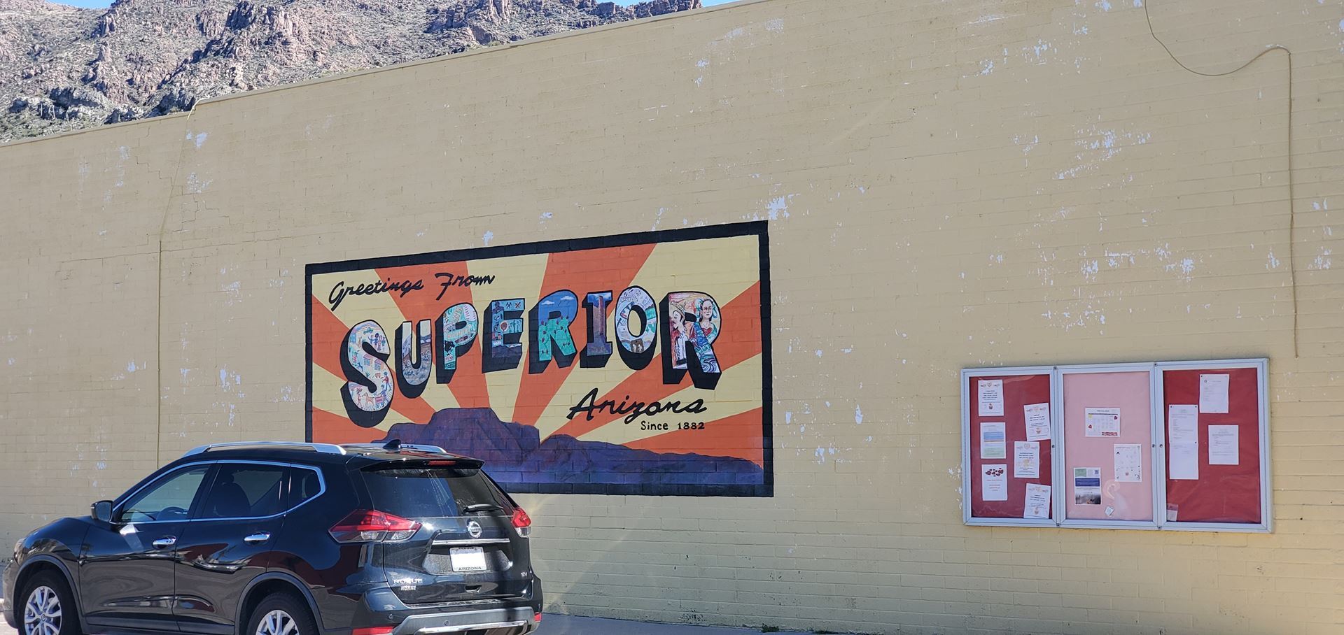
I reached Superior and wanted to find a place to get some coffee and snack. However, most of the businesses were along the highway and consisted of gas stations and mini-marts. In my experience, not the best places to find good coffee. I noticed a sign that directed me to "Historic Downtown Superior Arizona" and some local businesses that was located off the main highway. I decided to take that route to hopefully find a place to get coffee. But first I had to check out the "World's Smallest Museum" which was located across from the downtown turnoff. The "World's Smallest Museum" turned out to be a shed filled with "artifacts" (to use the term lightly) with the most notable feature being the roof that was made of hundreds of aluminum cans. Imaging the noise it would make during a hail storm.
I turned up the road to "Historic Downtown Superior" and found it to be nearly deserted. Most of the businesses were closed. I kept going in hopes that there would be a place to eat. I passed the "Superior Police" station. I don't know if "Superior" is a noun or adjective. About a mile into the downtown I came a cross a small coffee shop and it was open. Yea! There were also customers inside enjoying a beverage. I parked my bike next to a horse hitch rail and went inside. There I found what turned out to be the highlight of the day.
 Statue in Historic Downtown Superior AZ.
I bought a coffee and a peanut-butter cookie and sat back to enjoy the live music of a local musician, Billy Shack. He was sitting in the corner playing a guitar and singing cover tunes of country music and rock and roll. As I was sitting there enjoying the music, cookie and coffee, I realized I was almost missing an opportunity. I quickly got up and went to my bike to retrieve my GoPro camera. I went back in and when Billy had finished his song, I asked him if I could film him performing. He graciously said yes and I set up my camera on the tripod in front of him. He then played me an original song that he had written and performed for a movie soundtrack. He also gave me permission to publish the performance on my YouTube channel. Click the link at the bottom of this post to enjoy the song.
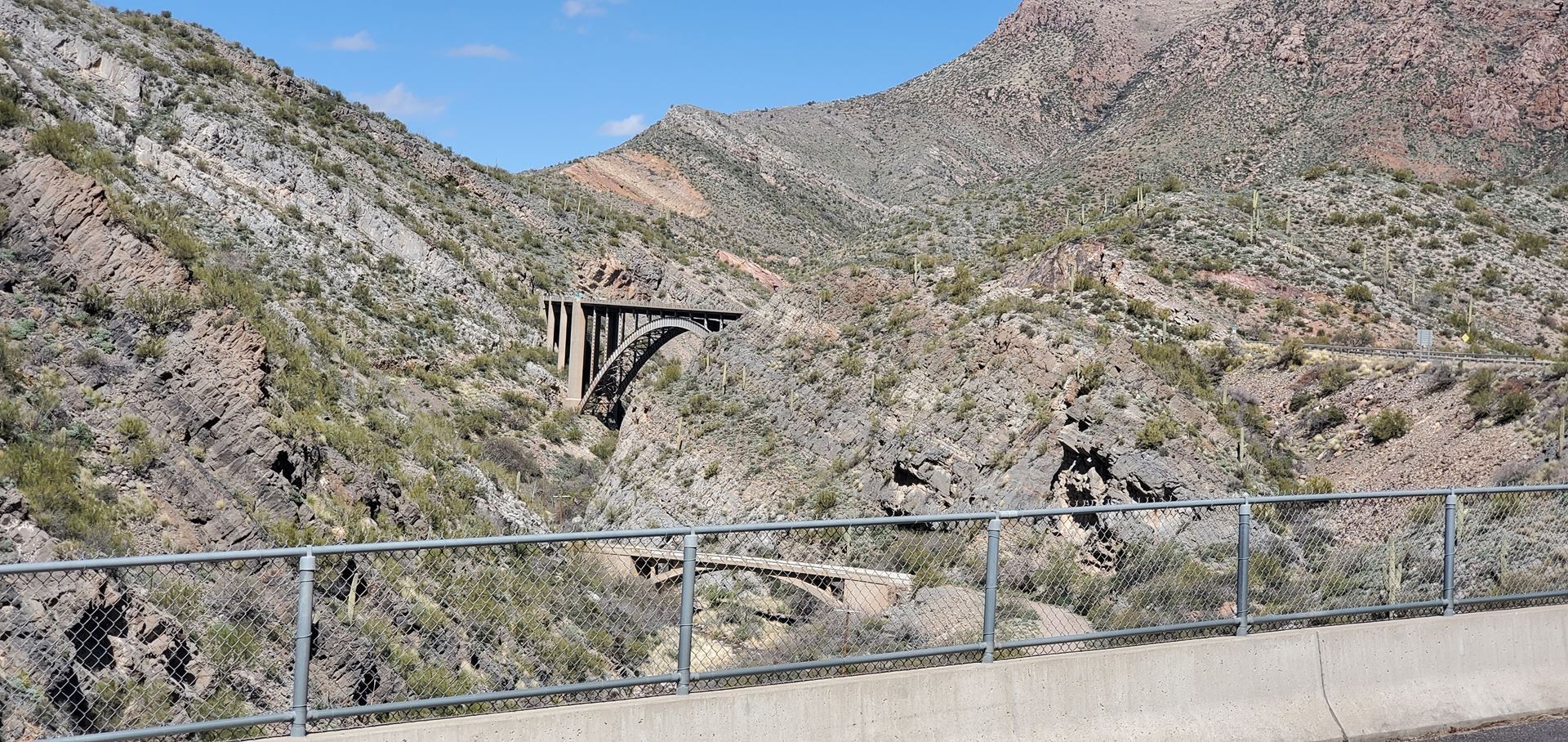
While I was enjoying my coffee, my wife was nearing Superior and we arranged to meet at one of the gas stations. I headed back towards the highway and met her and helped fill up the support vehicle with gas. I then began the second half of the climb and the steepest part. I also had to traverse the tunnel. My wife would drive ahead and leapfrog with me by pulling over at the various turn-outs along the climb. This part of the climb was on very narrow roads and we weren't sure what the conditions through the tunnel would be. We though she may have to shuttle me through if the conditions were too dangerous.
The climb, despite being narrow, was extremely beautiful. When I reached the tunnel my fears were alleviated as it had two lanes going up and a bike line beside it. There was only one lane of traffic descending through the tunnel. The only bad thing about riding in the tunnel was the extreme noise of cars that echo throughout. I safely made it through and continued to the summit.
 View of the climb out of Superior AZ.
Next was a 14 mile descent in which I was hitting speeds in excess of 40 mph. I would have gone faster, but I was unfamiliar with the road so I wasn't risking it. I'm glad I wasn't riding the opposite direction as the descent would have been a climb with an average grade of 7% for the whole distance. Next stop would be Globe Arizona, where we would have lunch. But first I had to go through "Top of the World" Arizona, population 3?
Top of the World, Arizona consisted of a house and a building that once housed "antiques" to use the term loosely. However, despite the signs along the way that said, "Save Top of the World", it appeared that there was no saving it. It was abandoned and boarded up. Well, on to Globe and lunch.
I made it to Globe around and was ready to eat. My wife had driven ahead and found an Italian restaurant and texted me the location. This is when the brilliantly great day started turning bad. Globe Arizona's main road is the highway. It consists of two lanes each direction and no shoulder. The built the curbs right up to the edge of the highway which leaves no room for cyclists. I therefore had to take the right lane for myself. oh, by the way, it was still all up hill through the town in the direction I was traveling. Now, I don't know if it's the residents of the town or just people traveling through, but most of the motorists had no respect or patience for a cyclist. Instead of waiting to pass me on the left, they would just drive up close behind me and blare their horn and shout profanities at me. Stay classy, Globe Arizona.
I eventually made it to the restaurant and we enjoyed a good lunch. We talked to the waitress and got information about the road ahead. She advised that it wouldn't be a good idea riding through the Apache Indian Reservation that was outside of Globe. She said that the roads are narrow and the drivers are reckless. I dismissed the advice and decided to continue on.
I still had to climb my way out of Globe for a couple of miles and the drivers stayed true to form. Way to go, Globe. I finally made it outside the town limits and there was a narrow shoulder for the next few miles. The road seemed safe and my wife proceeded ahead. However, soon as I entered the Reservation, the shoulder disappeared. There was only one lane each direction and the white stripe on the side had a rumble strip carved into it forcing me to ride in the lane of traffic. There was also a lot of truck traffic on the road in both directions making it very dangerous. I should have heeded the waitress's advice. I pulled over and called my wife. I asked her to stop at the next safest spot and let me know which mile marker she passed. I was about six miles behind her, so I told her to wait for me and we would shuttle in to Safford from there.
I reached her safely and placed the bike in the car. We drove the rest of the way to Safford. The Reservation was more than 40 miles wide and the road conditions remained consistent the whole way. With the late afternoon traffic, this road is too dangerous for cyclists. I think it would be potentially safer riding in the early morning.
Check out the Full Video here: https://youtu.be/hdzLMsshtdI
Donate here:https://www.valleychildrens.org/foundation/cycling-across-america
The Original planned route: https://www.komoot.com/tour/1026770644?ref=aso&share_token=aOz2RT2nKhhGp6iH9L41o02BkcIA1pS7nbM7oiqgTK3zjwvdYA
Check out my activity on Strava: https://strava.app.link/k7U1z5vZczb
Check out my activity on Strava: out my activity on Strava: